
Bike Basics
Of the three disciplines, biking is the one that will likely require the most work for the parent. Even adults struggle to find safe places to ride in our state, and this is doubly so when considering the needs of a child who doesn’t fully grasp the rules of the road. Luckily, we are here to help.
When getting started, the emphasis should be on drills and skills. The focus should never be, “how can my child go ___ mph on the bike?” but rather, “how can I teach my child to control their bike once they can go that fast?” Ultimately, all of the power in the world is useless on a bicycle if you can’t properly control it. Focusing on speed over skills often comes with dangerous consequences. Please check out our Bike Workouts for several bike control drills your child can practice in your street/driveway.
It should go without saying that your child should always wear a helmet. If you want a bicycle helmet to actually provide life-saving protection, please be mindful of the “two finger rule” and adjust the helmet straps accordingly to be sure the helmet fits snugly according to the rule. Please also note that per USAT rules, failure to wear a helmet will result in automatic disqualification.
If and when your child is ready, there are plenty of youth cycling events in Florida, with USA Cycling as the governing body. We highly recommend you contact the race promoter prior to signing your child up for any road event, as the level of road closures and youth safety precautions often vary. Know what you’re signing up for in advance. Novice riders should absolutely stay away from open road courses unless/until they have regular experience riding with an adult group.
Finally, we understand that youth road bikes are increasingly hard to find and service these days. That’s why we’ve created a buyers guide specifically focused on finding bikes to fit smaller riders (namely bikes with smaller than 700c standard wheels ).
Kids Road Bike Buying Guide
First and foremost, you do not need to buy your child a road bike in order for them to participate, enjoy themselves, and benefit greatly form the sport of triathlon. If you’re reading this, and you’re on the fence as to whether your child’s bike is good enough for a youth triathlon, assuming that it has working brakes and air in the tires, it is. Its much easier to do your first triathlon on a bike you’re already comfortable with, and that means the best bike for your kid to start with is the bike they already have.
That said, much of this site is geared towards kids who want to pursue triathlon as a sport, and we have some advice for parents looking to purchase a road bike for their child. (If you’re looking for generalized advice on kids bikes, here are two helpful sites.)
When it comes to buying any bike for your child, fit should be the number one consideration. It is important to resist the urge to buy a bike that your child will ‘grow into.’ This is doubly so on a road bike. Road bikes are not known for their ease of maneuverability, even when appropriately fitted. Placing your child on an oversized road bike only compounds this, and can create a difficult and often unsafe learning curve. For that same reason, if/when you are looking to upgrade parts on an existing kids bike, the focus should be on parts that will improve bike fit (handlebars and cranks for example).
Beyond safety, placing your child on an appropriately sized bike will force them to learn aerodynamic riding positions and train the muscle groups that will make them a strong adult rider someday. Trying to stretch a child onto a larger frame bike will typically result in an upright (i.e. slower) riding position more akin to a mountain bike or cruiser. There will be some fit and/or bike control compromises if you’re trying to squeeze a 700c wheel on a frame smaller than 47cm. Thus, we recommend you opt for a smaller wheel for anyone below 5 feet tall.
Unfortunately, it is getting harder to find bikes which are a good fit for kids because of market forces. Bike companies are partially in the business of reselling components. Finances usually push companies to include only one wheel size (700c) in their product lines, and design xs or xxs frames around that size. This need to streamline components, combined with the ongoing exodus from road cycling to mountain biking, means that there are no longer any major companies that sell a “true” kid-sized road bike. However, there are a few companies that still sell cyclocross/gravel bikes sized specifically for kids, as follows:
BikesDirect (budget-level entry)
Even though new bikes are few, if you are patient, there are still plenty of good options floating around Facebook Marketplace, Craigslist, and the like. Please use the guides below, which lists the models you are most likely to see, broken down by stated wheel size, and has included pictures of each. Please note that many of these models ran for several years, and were not always specced exactly the same (some years were 9 speed instead of 8, etc.).
Because tires and tubes in these sizes are becoming less common, the guides include the actual wheel diameter of each. (It is generally a good idea to ensure you have a source for replacement tires/tubes before purchasing any bike.)
The majority of remaining kids road bikes will either be 24 inch, or 650c/26inch. Though every kids is different, the age range on 24 inch bikes is generally 8-10 years old and 10-12 years old (and possibly beyond) for 650c. Please note that 650c and 26 inch are not the same size, and that there are 3 different diameters that are regularly sold as 24 inch wheels. There are a few 20 inch road bikes available here and there for the under 8 crowd, but they are incredibly rare, relatively speaking.
For more information on wheel sizes, please see the following link).
Places To Bike
While Florida is full of bike lanes, those who brave our streets by bike know that they vary widely in safety. The fact is, many adult group rides are only made safe due to the large number of riders. We do not recommend you teach a young rider to ride a road bike in an unprotected bike lane. For that reason, we have broken our riding locations into sections, starting with areas that are (mostly) car free, followed by a few places with limited cars.
Car Free and Limited Stop Options – Each of the places below are bicycle or mixed use trails which do not allow motor vehicles (except service vehicles and trams), and all contain stretches of several miles with no crossings. Unless you’re crossing a street, cars will not be an issue.
Flatwoods Conservation Park – Flatwoods is a 7 mile, paved loop, which has two main connector trails (one approximately 2 miles long, and another less than a mile long) that can be accessed by parking at two different locations; Bruce B Downs (westside), and Morris Bridge (eastside), respectively. Parking costs $2, and there are restrooms at both parking locations. There are no restrooms out on the main loop, but there are plenty of water stops along the way.
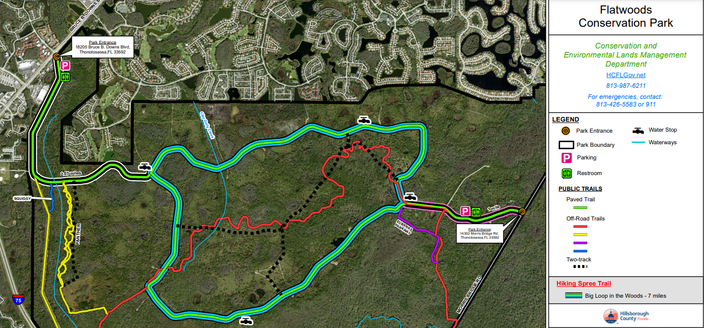
(Image courtesy of www.hcfl.gov)
Flatwoods, as its name suggests, is very flat. Traffic flows one way only, in a counter-clockwise direction. In other words, there is no turning back, and you should keep this in mind when planning your route. Your mileage will thus be 7 for every lap you take, plus either 4- or 1-mile depending on where you park.
If you are planning on biking fast, please save your energy for the main loop. The connector trails that lead to the main loop are typically filled with runners and children, and you should take it slow in these areas.

Flatwoods sits in a low lying area, and is prone to seasonal flooding. You may want to ask around on Facebook to see what the current conditions are if/when it has been particularly rainy. Of the two entrances, the Morris Bridge is generally the nicer of the two: it has a shaded picnic area and isn’t usually as crowded as Bruce B Downs. However, Bruce B Downs sits next to several post-ride food spots such as Panera, Dunkin, and Chick-Fil A.
Finally, please note that if you veer off to the southwest from the Bruce B Downs entrance, you can make a side trip by bike to New Tampa Nature Park, which has a free zipline.
Jay B Starkey Wilderness Park – Located at 10500 Wilderness Park Blvd, New Port Richey, FL 34655. Parking is $2. While the bike trail at Jay B Starkey Wilderness Park (“Starkey”) could technically be considered a 6.5 mile connector with the Suncoast trail, it merits standalone inclusion on this list. Starkey is the largest wilderness preserve in Pasco County, and the paved bike trail runs straight through the middle of it. Starkey also has a large playground, and a camping area with primitive cabin rentals and showers. If you’re feeling adventurous, there is even a primitive campsite that abuts the main bike trail around 5 miles in, which you could easily bike-pack. In addition to the paved trail, there are several beginner mountain bike and hiking trails.
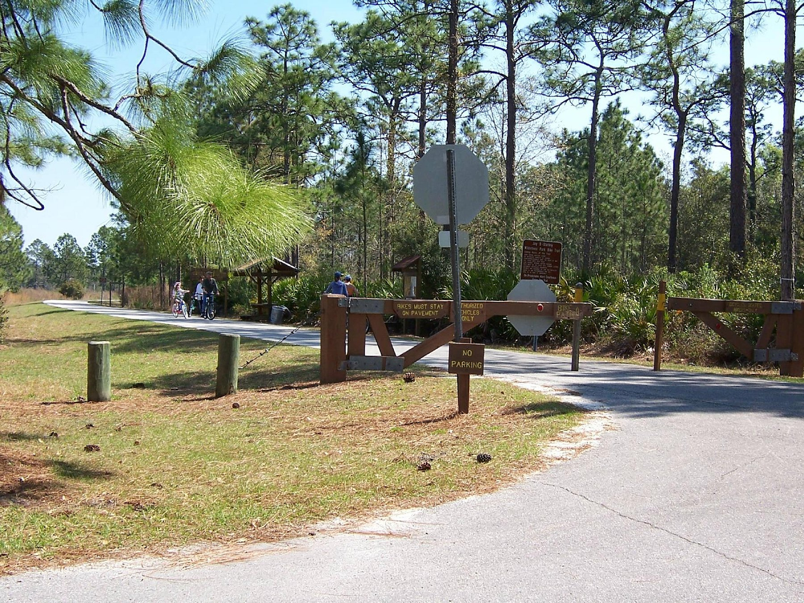
(Image courtesy of Tripadvisor.com)
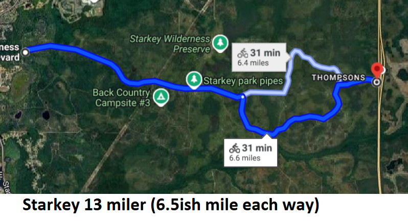
The trail was repaved in October of 2023 and is in great shape. Most of the foot traffic is within the first few miles, which also features a “solar system” where there are signs for each planet placed according to their distance from the sun. The trail gives you a north and south option, and ends at the Suncoast Mile Marker 22.9, where there is a full bathroom, and pavilion. This serves as either a great turnaround for beginners on a 13ish mile out/back, or a springboard for further adventures on the Suncoast Trail. Below we have posted a map showing the 13ish mile route, as well as a 25ish mile option, that incorporates the Suncoast trail without requiring any street crossings. If you aren’t quite ready for that, Starkey is still a great spot to do an out and back at any distance. It’s an ideal beginner spot because it is pancake-flat throughout.

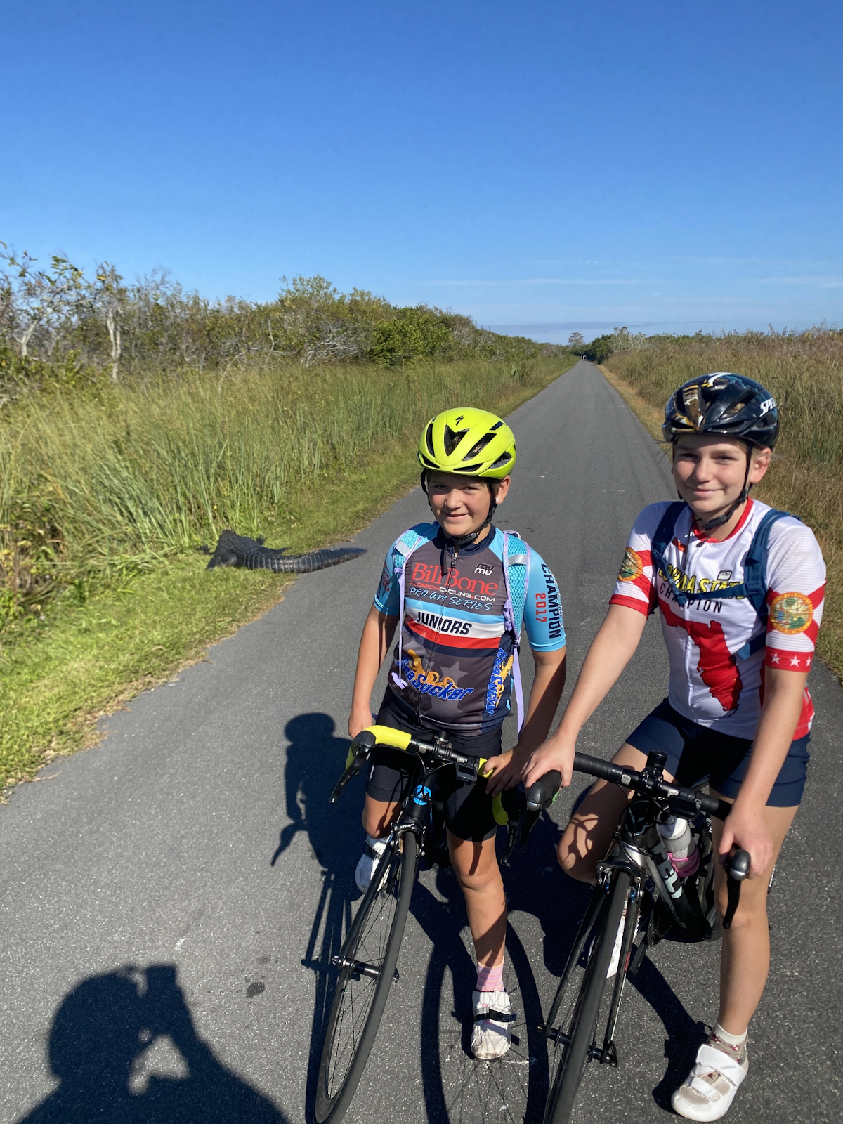
Shark Valley Loop – Located at 36000 SW 8th St, Miami, FL 33194. Shark Valley Loop is on the pricey side for a bike ride, as it costs $35 to get into the park (which is good for 7 days thereafter), but it is an amazing experience that all Floridians should see in person at some point in their life. The park has a 15 mile loop which is roughly 8 miles one way, and 7 the other. There are restrooms and (limited/expensive) concessions at the entrance, and restrooms at the turnaround point. We recommend you pack a lunch in advance, as it’s in a fairly isolated area, with few food options nearby. There are also no water stops until the tower, so you will need to pack at least 2 full bottles per person.
(Image courtesy of miamiscapes.com)
The main draw of Shark Valley Loop is the beauty of the Everglades, and the animals you get to see along the way. The park is chock-full of alligators, turtles, and other various creatures, including the occasional salt-water crocodile. It has even been host to viral moments, such as when an Alligator was seen ingesting a Burmese Python in late 2024. Additionally, the 45-foot observation tower located at the turnaround point is an excellent reward at the halfway point, as the views are often stunning. If you’re experienced enough to make the loop, it’s a much better way to enjoy the park than waiting an hour (or more) to catch a sightseeing tram.
The biking itself is as easy as it is flat. The only caveat is that there is nothing to block the wind on the prairie, so windy days could pose an issue. Finally, while they do rent bikes onsite, we highly recommend you not take this trip without bringing your own bike, as the onsite fleet is composed of single-speed cruisers, in various states of repair. Aside from the real possibility of running over an alligator, the only safety issue to be aware of is the need to yield to the tram if you see it.
If money were no issue, and if it were not located roughly an hour from civilization, Shark Valley would likely be packed to the gills with cyclists at all times. It is a wonderful place to spend a day if you’re willing to invest the time, and should be on your Florida bucket list whether or not cycling is your thing.
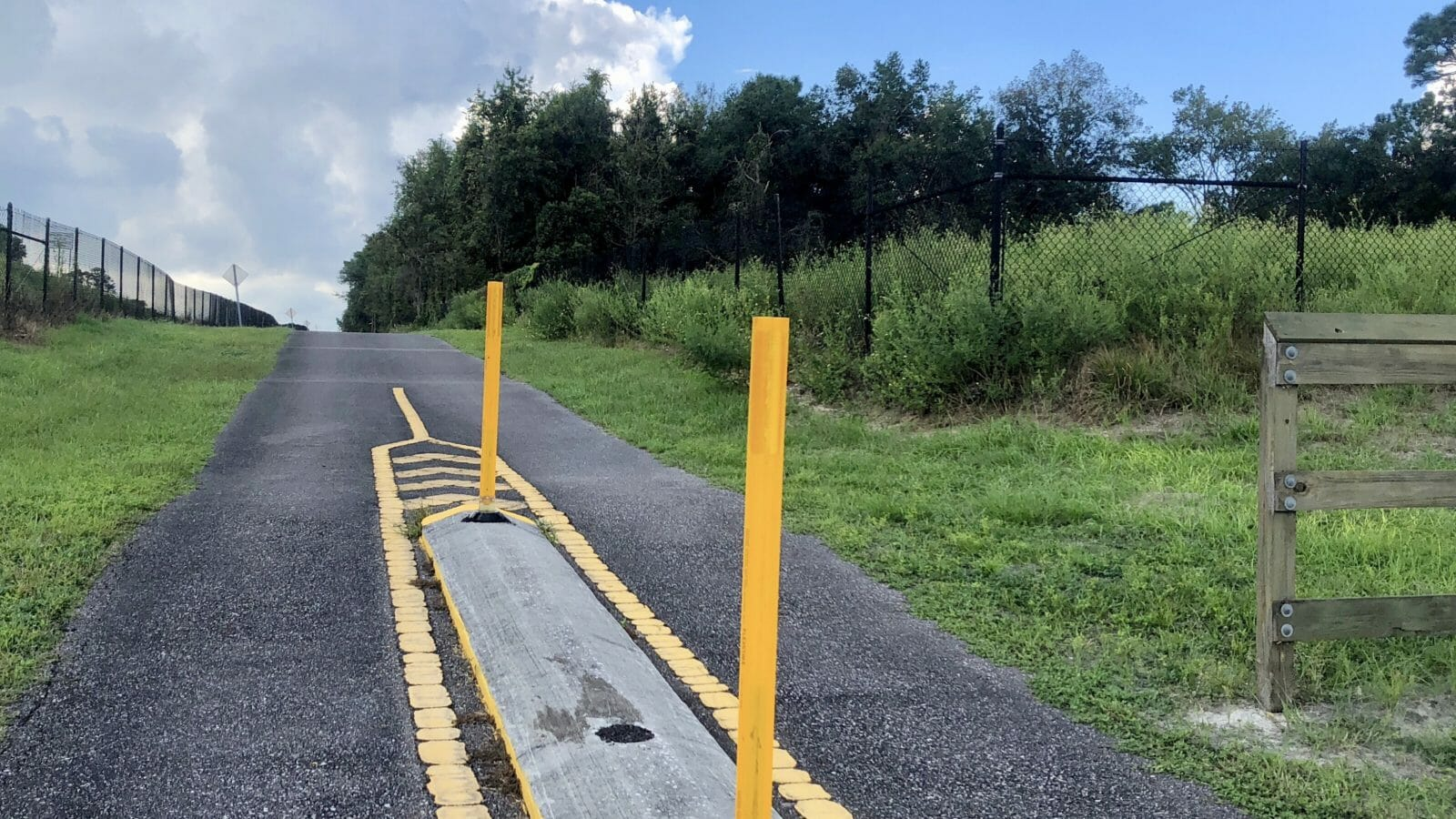
Suncoast Trail (Northside) – Trailhead located at 17325-17331 Suncoast Trail, Spring Hill, FL 34609. While there is supposedly a parking fee of $2, the County has removed payment boxes in recent years, and it is unclear if parking fees are still required or enforced. We’d recommend you bring $2 just in case.
(Image courtesy of floridahikes.com)
As you may have noticed, none of the routes listed thus far have any hills to speak of whatsoever, including the sections of the Suncoast Trail that connect with Jay B Starkey Park. However, once you go north into Hernando County, the geography quickly changes, and there are (at least by Florida standards) substantial hills. The best spot to park and ride these hilly spots is to park at the SR 50 trailhead, and ride north from there (you can go roughly 20 miles or so north). The SR 50 trailhead has both restrooms and a picnic pavilion.
(Image courtesy of Google Images)
While the north sections of the Suncoast Trail do not have many cross streets, you need to exercise special caution at a few of them. For example, CR 476 is a 2 lane highway where there is no stoplight and cars regularly travel in excess of 55 mph. The trail also tends to accumulate a lot of leaves and acorns, so be mindful of this when descending downhill since it can make things slippery. Those minor issues aside, it is generally a good place to introduce kids to hills and has adequate rest stops (picnic tables) spaced throughout.
Van Fleet Trail – Trailheads at 12201 Co Rd 772, Webster, FL 33597 (Mabel/North), 4903 Green Pond Rd, Polk City, FL 33868 (Green Pond), 7500 South Bay Lake Rd, Groveland, FL 34736 (Groveland) and 7683 Berkley Rd, Polk City, FL 33868 (Polk City/South). Free parking at all locations. (Please note that for some reason, Google has trouble finding the Green Pond trailhead.)

(Image courtesy of Flordastateparks.org)
The Van Fleet is one of the few truly isolated places remaining in Central Florida. Heading south from the Mabel trailhead, you go nearly 10 miles without a single cross street. On your way you may get the chance to see all kinds of wildlife including deer, alligators, turtles, and rabbits. Please keep your eyes peeled for spray painted portions of the road, as the State Parks service does their best to identify and mark potholes and small bumps.
The trail was once a railroad, and thus runs in nearly straight-line fashion throughout. As such it is very easy for beginners, and an ideal location to find your top cruising speed. You will definitely see a few time-trialers while you’re there. The entire trail is 30 miles in length, with the Green Pond and Groveland trailheads spaced up roughly 10 miles from the North and South trailheads, respectively. This trip requires planning ahead, as there are no water stops along the way, and (except for the Polk City trailhead) none of the trailheads are located near towns.
If you’re looking for an easy, quiet ride away from the crowd, Van Fleet is the place to go.
Limited Traffic Options
Cars are by far the biggest obstacle to a safe ride for you and your family. Florida has grown by 3.4 million people in the last 10 years alone, and consequently, there are fewer and fewer places to safely share the road. That said, we do have a few to recommend when you are ready.
Lake Louisa State Park – Entrance located at 7305 US-27, Clermont, FL 34714. Cost of admission is $5 per vehicle, or free with a Florida Parks Pass.

Lake Louisa State Park makes both our swimming and biking lists, and is generally a triathlete’s paradise. Every weekend you will see the park packed with time trailers. Because it is a state park with low speed limits, drivers are generally more mindful and in less of a hurry. This park is also a great place for learning how to safely navigate hills.
There is a camping area and air-conditioned cabins suitable for families of up to 6. Both the cabins and the campsites can be booked through the State of Florida, and you will likely need to book several months out. There is also a private company that rents “glamping” tents. The park also provides guided horseback tours for an additional fee.
There are full restrooms and showers near the beach area at Lake Louisa and an outhouse at Dixie Lake. There are limited concessions at the camp store.
The biking is scenic, and nothing like the landscape you’d expect to see in Florida. If you arrive early enough, you are likely to encounter deer. If you arrive in the afternoon, you might spot some gopher tortoises. The hills are generally challenging for a beginner, but still manageable. If your child isn’t quite ready for the biggest hills in the park, you can stay in the inner loop, which is roughly 3 miles as shown below.

Once you are ready for a bigger challenge, the entire park has a 10 mile loop as shown below.


SWIM
Learn About Swim Basics, Places to Swim, and Swim Workouts

BIKE
Learn About Bike Basics, Places to Bike, and Bike Workouts

RUN
Learn About Run Basics, Places to Run, and Run Workouts

UPCOMING RACES
Learn About Youth Races and Draft Legal Races